Grünberg - Haiminger Alm mountain hut
Learn more
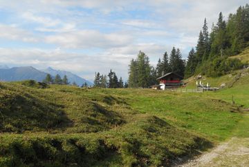
From Grünberg car park, follow the signs towards Simmering. After following the forest road for about an hour, you'll come to Zwischensimmering where a bench at the side of the path invites you to take a short break. From there, turn right and follow signs towards the Simmeringalm. As soon as you pass the first bend, turn left off the forest road to follow the Harnersteig trail into the beautiful forest. The trail snakes slowly up the mountain until it comes to a fork in the path with a sign that points left to the Haiminger Alm mountain hut. If you turn left, you come to an alpine meadow with a hunting lodge: the Harnerhütte.
A discreetly signposted path leads through the meadow past the hut. From there, the route continues along a narrow hiking trail for about 45 minutes and then joins a forest road. After about another fifteen minutes, you reach the rustic Haiminger Alm with its wonderful alpine pastures and fantastic views of the Inn Valley and the Stubai Alps.
The route back initially follows the same forest road. When you come to the fork, however, the route diverges from the path to the Simmeringalm and the Harnersteig trail and instead follows the hiking trail that leads through the forest above the Inn Valley. Continue along this trail for about an hour to Zwischensimmering. From there, follow the same forest road back to the starting point.
Highlight:
- "Inntalblick" viewing platform (1,320 m): On the way back, it is well worth taking a detour from Zwischensimmering to the "Inntalblick" viewing platform. The walk from Zwischensimmering takes about 15 minutes.


